
Overview:
If you haven’t already done so, please be sure to check out my post on Course #1 because I provide some relevant information about this coastal trek. If you’re interested, there’s a comprehensive website complete with trail maps and information, but it’s all in Korean. You can check that site out here if you wish. Below is a map I made with the help of Naver Maps that shows both trekking courses:

Course #2 Specifics
Unlike Course #1 which had a total of 12 sections and totaled 22.5km, Course #2 has just five sections and covers 17.0km of Dolsan Island’s eastern coast. It begins where Course #1 finishes, and that’s at Mulsulmok Beach. At the finish, you’re rewarded with the nice and sandy Bangjukpo Beach. Below is a map from getga.org and like before, I’ve added the start and end points of Musulmok and Bangjukpo beaches, respectively.

Similar to Course #1, this second course winds its way up and down and around the cliffs and shorelines of the beautiful and rugged coast of Dolsan Island. Course #2 is also marked with with a combination of posts (to distinguish sections), blue spray-painted turtles, and yellow/orange trail ribbons.

Hiking Highlights:
After a successful day completing Course #1 on Saturday, we camped at Mulsulmok Beach and woke up around 8:30am, much later than originally planned. Our goal was to hit the road by 7:00am, but that just wasn’t in the cards! Elicia and I packed up our tent, hammock and other belongings and found out the others were pretty tired and sore and preferred to lounge around and head back to Suncheon instead of hiking Course #2. After all, we just hiked over 25.0km yesterday and the thought of hiking another 17.0km was a bit daunting given the heavier-than-normal packs and heavy, tired legs. So, just Elicia and I rolled out of Mulsulmok Beach, making our way across the rocky beach and into the woods. Tired, but ready to go:

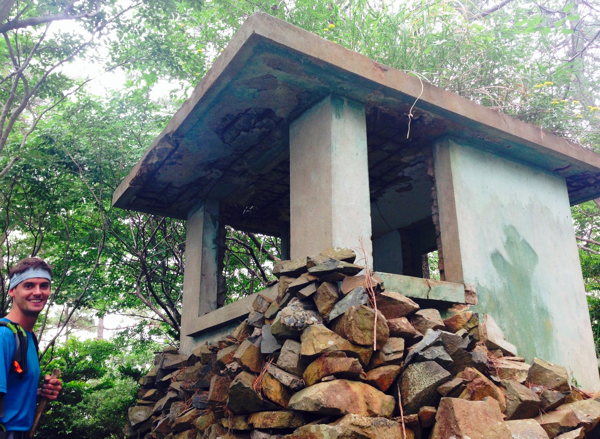
We quickly noticed the number of military bunkers, buildings, and shelters that were along Course #2. Personally I thought they were really interesting, and I wondered if the Korean military uses them today for any training operations or as observation decks.

The weather on this Sunday wasn’t as clear as the day before, but it wasn’t threatening rain. The temperature was significantly cooler, so we welcomed that. We also enjoyed the coastline, and we found a spot very similar to this to have a late breakfast (or early lunch?) around 11:00am.

One unique section included an open field where two goats were hanging out, one on each side of the trail.

I love the noise these animals make.

So, after the goat-excitement we continued along the trail, making pretty good time in the overcast but beautiful conditions. The visibility out into the sea was pretty minimal, so I didn’t capture too many pictures along this course. However, I’d say there were far less villages and houses to walk by on this second course compared to the first course.

After about three hours of hiking and maybe 10km into the second course, we came across a fairly big military area. There were no people, but clearly it was used for observation or training purposes in the past. We poked around for a while and I began thinking about the Korean War in the early 1950’s and how it really wasn’t that long ago. My oh my how this country of South Korea has built up since the completion of the war. It’s cool that bunkers like these are still there, letting nature take them back.

About 14km into the trek (roughly 3km north of Bangjukpo Beach) there’s a big, white lighthouse out on a little peninsula. Elicia and I sat down here for a while to eat and drink till our hearts were content. By this time it was nearing 1pm and we were almost done with the second course!

I’d say the second course had a few more ups and downs than the first course, but they are pretty similar in elevation change. Towards the end of this Course #2, the trail stays tucked in the woods, somewhat high up along a ridge. Walking south, the sea is on your left and the mountains on your right. This particular stretch was really quiet and peaceful. On Saturday, we saw about three other hikers besides our group of eight people. On Sunday while trekking Course #2, Elicia and I saw a few couples and maybe one other person. In other words, you can definitely hike most of this trail and feel like you’re the only one(s) out there.

Around 2:00pm Elicia and I rolled into Bangjukpo Beach, so the 17.0km took us about five hours to complete. We did take a couple breaks around the military areas and to snack, but otherwise we kept a pretty good pace, especially along the flat areas.
All-in-all, I am so pleased the group from Suncheon organized this trip out to Dolsan to explore these courses. I’d highly recommend them for any hiking/trekking enthusiast, and I was again surprised by the natural beauty the southern coastal area of Yeosu has to offer. I’m continually amazed that mountains, coastline, and trails like these are just out our back door. I’m excited to explore the third (and fourth?) course(s) soon, I anticipate the next courses will be just as spectacular as the first two.
Doing both of these courses are possible on a Saturday/Sunday like we did, but you could also do any segment of the course and fairly easily catch a city bus back north towards Yeosu. If you have any questions or comments about this coastal trek, please let me know as I’d be happy to help you out.


A great photo reportage! The goats always make me smile :)
Thank you!!
Wow, looks really cool. Maybe now that we have a car, we can easily check that one out. Thanks Tom!
Thanks! What kind of wheels did you get… and more importantly, does she (or he?) have a name yet? Car = freedom. We should plan something epic.
Hmm, no name. We still need to get to know each other first I guess. I learned that my scooter had already been named so I guess pressure looms. Yes, definitely up for something epic! Camping/hiking sounds good for us but far away beaches are also on the radar of fun. Get in touch. I just got a phone as well. Will email you the details.